


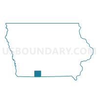
CLINTON TWP Voting District, Ringgold County, Iowa
About
Outline

Summary
| Unique Area Identifier | 583326 |
| Name | CLINTON TWP Voting District |
| County | Ringgold County |
| State | Iowa |
| Area (square miles) | 28.07 |
| Land Area (square miles) | 27.94 |
| Water Area (square miles) | 0.13 |
| % of Land Area | 99.55 |
| % of Water Area | 0.45 |
| Latitude of the Internal Point | 40.60764580 |
| Longtitude of the Internal Point | -94.41762140 |
Maps

Graphs
Select a template below for downloading or customizing gragh for CLINTON TWP Voting District, Ringgold County, Iowa


Neighbors
Neighoring Voting District (by Name) Neighboring Voting District on the Map
- BENTON TWP Voting District, Ringgold County, IA
- BLOCKTON Voting District, Taylor County, IA
- Fletchall East Voting District, Worth County, MO
- Fletchall West Voting District, Worth County, MO
- GAY TWP Voting District, Taylor County, IA
- JEFFERSON TWP W/O BLOCKTON Voting District, Taylor County, IA
- MIDDLE FORK TWP Voting District, Ringgold County, IA
- RICE TWP PART Voting District, Ringgold County, IA
- West Union Voting District, Worth County, MO
Top 10 Neighboring County Subdivision (by Population) Neighboring County Subdivision on the Map
- Fletchall township, Worth County, MO (1,072)
- Union township, Worth County, MO (460)
- Jefferson township, Taylor County, IA (294)
- Middle Fork township, Ringgold County, IA (238)
- Rice township, Ringgold County, IA (217)
- Clinton township, Ringgold County, IA (208)
- Benton township, Ringgold County, IA (110)
- Gay township, Taylor County, IA (80)
Top 10 Neighboring Place (by Population) Neighboring Place on the Map
Top 10 Neighboring Unified School District (by Population) Neighboring Unified School District on the Map
- Mount Ayr Community School District, IA (4,180)
- Bedford Community School District, IA (2,894)
- Worth County R-III School District, MO (2,216)
Top 10 Neighboring State Legislative District Lower Chamber (by Population) Neighboring State Legislative District Lower Chamber on the Map
- State House District 3, MO (35,529)
- State House District 4, MO (35,512)
- State House District 96, IA (26,979)
Top 10 Neighboring State Legislative District Upper Chamber (by Population) Neighboring State Legislative District Upper Chamber on the Map
Top 10 Neighboring 111th Congressional District (by Population) Neighboring 111th Congressional District on the Map
Top 10 Neighboring Census Tract (by Population) Neighboring Census Tract on the Map
- Census Tract 9502, Ringgold County, IA (3,020)
- Census Tract 9601, Worth County, MO (2,171)
- Census Tract 9501, Ringgold County, IA (2,111)
- Census Tract 1802, Taylor County, IA (2,092)